The Science Behind Hurricanes
Andrew, Charley, and Irma. Say any of those three names and Florida residents are immediately reminded of the damage done by three of the most devastating hurricanes to hit the state. Tropical cyclone is the scientific term for all of these storms (NASA, 2018). Whether you call them typhoons, cyclones, or tropical cyclones, there is no denying that these storms have the potential to be violent and devastating to the communities that they hit. Hurricanes are the most violent storms on Earth (NASA, 2018). A tropical cyclone is only called a hurricane when it forms over the Atlantic or in the eastern Pacific (NASA, 2018). We all know that these storms can do some damage, but how do they form? What is the science behind these potentially detrimental natural disasters?
Warm ocean water is necessary in order for a tropical cyclone to form. Tropical cyclones will only form where the ocean is 80 degrees Fahrenheit for at least the first 50 meters (approx.. 165 feet) below the surface ( NOAA, 2018). Wind is the second necessary component in order for a tropical cyclone to form. In Florida, the hurricanes form in the Atlantic. The wind that blows westward from Africa across the Atlantic combined with the warm ocean water creates the perfect combination for a hurricane to develop. As the wind passes over the surface of the ocean, it evaporates. The water vapor cools as it rises up and then condenses into large water droplets, forming large cumulonimbus clouds ( NOAA, 2018). These clouds are the start of a tropical cyclone.
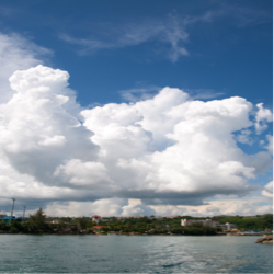
Cumulonimbus clouds
NCPedia, 2018
There are four stages in the development of a tropical cyclone that meteorologists use: Tropical disturbance, tropical depression, tropical storm, and tropical cyclone.
Stage 1: Tropical disturbance, Winds from 0-24 mph
When the water vapor from the ocean condenses in order to form clouds, heat is released into the air. The air is warmed from the heat that has been released. The warm air is then pulled into the column of clouds (NOAA, 2018). The cloud columns are continuously being added too due to evaporation and condensation occurring. The cloud columns become taller and larger. A pattern develops and the wind continues to circle around the center (NOAA, 2018). This air column will continue to move and as it encounters more thunderstorm clouds, it will continue to grow and be classified as a tropical disturbance.
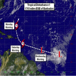
Tropical Disturbance
Source: BVI hurricane, 2014
Stage 2: Tropical depression, Winds from 25-38 mph
The air at the top of the cloud column will cool and destabilize as the column continues to get higher and larger. As the water vapor cools, heat energy is released causing the air at the top of the clouds to warm up. The warming of the air at the top of the clouds makes the air pressure higher. This causes the winds to move outward away from the high-pressure area. The surface pressures then begin to drop because of the warming and the movement. The surface air moves towards the low-pressure area, rises, and then creates more thunderstorms (NOAA, 2018). The winds in the clouds continue to spin faster and faster in a circular motion. The storm is called a tropical depression when the winds reach between 25-38 mph.
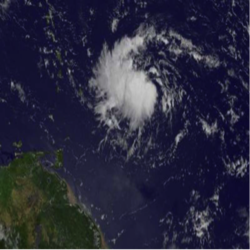
Tropical Depression
Phys.org, 2018
Stage 3: Tropical storm, Winds from 39-74 mph
The winds begin to blow faster and they rotate around the eye. The eye is the calm center of the storm. Wind direction is dependent on which hemisphere the storm is formed in. Wind direction is counter- clockwise (west to east) in the northern hemisphere and clockwise (east to west) in the southern hemisphere.
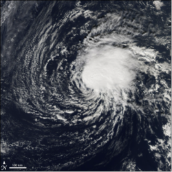
Tropical Storm
Source: Earth Observatory, 2006
Stage 4: Tropical cyclone, Winds from 74 mph
These storms are at least 50,000 feet high and they are around 125 miles across (NOAA, 2018). The eye of these storms can range from 5 miles to 30 miles wide. The winds that blow from east to west, called trade winds, push the storm towards the Caribbean, Gulf of Mexico, or towards the southeast region of the United States.
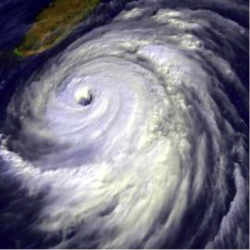
Tropical Cyclone
Source: NOAA, 2018
There are 5 categories of Tropical Cyclones. Below is a table that outlines each category:
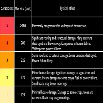
Tropical Cyclone categories
Source: University of Sydney, 2018
Tropical cyclones generally weaken when they hit land because there is nothing to fuel them since they are away from the warm ocean waters. Just because they weaken when they hit land, does not mean that they can’t do immense amounts of damage.
Hurricane season here in Florida has officially started. It began on June 1, 2018 and will not officially be over until November 30, 2018. Stay safe and be sure to pay attention to the weather officials in your local area!
References:
http://bvihurricane.com/tropical-disturbance-1-becoming-better-organised/
https://earthobservatory.nasa.gov/NaturalHazards/view.php?id=6169
http://www.geosci.usyd.edu.au/users/prey/Teaching/Geos-2111GIS/Cyclone/CLN012.html
https://www.ncpedia.org/anchor/how-does-hurricane-form
https://phys.org/news/2017-08-nasa-tropical-depression-east-lesser.html
https://pmm.nasa.gov/education/articles/what-hurricane-typhoon-or-tropical-cyclone
https://scijinks.gov/hurricane/
https://spaceplace.nasa.gov/hurricanes/en/